


MacKinnon Ravine Park in the Edmonton River Valley Part II: Hiding in Plain Sight and Concluding Remarks (July 6, 2024)
More than can meet the eye!

2.0 Hiding in Plain Sight
2.1 History and Culture
2.1.1 River Valley and Parks
The Edmonton River Valley Conservation Coalition has published on its website an outstanding socio/cultural/ecological history of Edmontons River Valley called “A brief history of Edmontons River Valley and Ravine Park System.” It starts with a discussion of our indigenous peoples in the valley, long before settlers and settler colonialism arrived. After Frederick Todd suggested the entire river valley be retained and kept as a park for people and nature in the early 20th century, the City set about to both acquire river valley lands, and allow industrialization of it (i.e., coal mining, gravel mining, lumber mills, garbage dumps, etc), displacing indigenous peoples along the way. A local engineer in 1910 in a report to Council had a utilitarian if not cynical view of ravines.
…the city’s ravines “can be utilized immediately as dumping places for stable manure and street refuse.” However, this was not a vision that condemned ravines to becoming receptacles for undesirables. Rather, these “dumps” would “prove valuable assets to the City as the need for fertilizer increases.
The Affordances of MacKinnon Ravine: Fighting Freeways and
Pursuing Government Reform in Edmonton, Alberta, Shannon Stunden Bower, 2016
As land acquisitions chugged along with mining, etc., in the early 60s the Province of Alberta amended planning legislation to require more rigorous planning approaches and processes. One of those outcomes was the requirements for sub area functional master plans, including parks. The 1970-1980 Edmonton Parks Master Plan was the first parks master plan in the history of the city, and included the river valley. More formal river valley park planning occurred in the early 70s through to the creation of the Capital City Recreation Park that has now been extended into a regional park in the river valley through the River Valley Alliance Plan of Action. I would encourage you to read the entire historical summary, by clicking the link below.
https://www.ervcc.com/brief-history-of-nsr
2.1.2 MacKinnon Ravine Transportation Corridor Contestation
While widely touted as the largest contiguous parks system in North America, Edmonton’s contemporary river valley is less the realization of a grand coherent vision for the region and more the outcome of a number of distinct,
if sometimes interconnected, processes bearing on smaller geographic areas.
Shannon Stunden Bower, 2016
In the early 60s Alberta new planning legislation required development of high level strategic planning documents called General Plans, now called Municipal Development plans, along with major systems plans, including parks, roadways and utilities. Edmonton was planning for a large influx of people to accommodate the single family home development desired by developers of the day, and away from our historical mixed use neighbourhoods. Over time, others saw the ravines as places for garbage dumps, roadways, sources of gravel, clay umber, etc.
The engineers of the City METS Plan determined in 1963 that the ravine was to be redeveloped for transportation freeways in the service of economic development, a link to a mid 20th century focus on major roadways and freeways to accommodate car orientated development. A public movement emanating from the University of Alberta started in the mid 60s to fight the transportation plan that ultimately successfully saved the ravine from destruction. Below is a podcast that talks about the debate. The METS plan included 3 major ravine roadways proposals, including Capilano and Mill Creek Ravine. Only the Capilano crossing was approved and constructed.
The protests against the freeway through the ravine was led largely by women and artists. Public misogynistic reporting referred to the opposition often as led by “housewives.” The Edmonton Journal even posted the address of one of the protesters in the newspaper, an artist named Marie Chappelle. The City slow walked development despite protests. They cleared the bush, removing some homeless camps. They put in utilities and started road construction. Finally in 1980, the freeway project was officially killed by City Council after multiple community protestations. Mackinnon Ravine Park was formerly named in 1984. The multi-use trail is the original roadway partially built. There are dirt and gravel trails periodically as well on the edges of the ravine. Those opposed to the freeway argued that the city should stop creating car orientated development desired by the development industry (i.e. who knew??), and instead proposed light rapid transit solutions to move people from the west to the downtown. A podcast describing the protests is provided below.
https://letsfindoutpodcast.com/2022/11/03/episode-58-the-mackinnon-ravine-mystery/
2.2 Climate Change … Man Plans, God Laughs
Climate change will be an enduring reality, an outcome decades in the making, that can and will impact both this site and the entire river valley. The river valley is home to much revered mature trees and permeable surfaces, that both act to ingest moisture, sequester pollution, reduce urban heat islands, reduce stormwater management costs, etc. As trees mature, the ability of them to survive increases with mature soil and root systems and fauna and flora ecosystems enclosed to some extent by the geomorphology (i.e.e steep grades). Edmonton has had periods of drought that stresses the trees. With or without the stress, urban forests are susceptible to fire. While fire is a normal regenerative process for forests, our river valley has largely protected from this natural process in order to protect property, people and urban infrastructure. Meanwhile, in recent years forest fires have ravaged the Province, displacing people and wildlife, and destroying forests at rates never seen before. To date this portion of the North Saskatchewan river valley has been spared… for now.
What happens outside the river valley impacts the river valley. Table lands were previously permeable surfaces (i.e., trees, farmlands, wetlands). As urbanization occurs, those permeable surfaces are substantially replaced by impervious surfaces such as roads, buildings, etc. Climate change increases the intensity and frequency of storms. The moisture generated by those storms no longer slowly sinks into the water table and the river valley. Substantial portions of the the moisture are now directed from roof leaders, into storm sewers pipes directed into the river valley, in volumes and intensity never before seen, mitigated only somewhat by storm ponds. These storm events will increase the risk of river valley flooding, loss of our natural heritages, damage or loss of recreational amenities such as trails, bridges, lighting, buildings, signage, park furniture, etc., not to mention loss of indigenous history and culture. Critter and public health and safety is being compromised by both fire and flooding. Densification of the table lands and climate change (i.e., more intense, frequent storm events), could potentially flood Louise McKinney Riverfront Park periodically and may damage the promenade, washroom amenity structure, and the boat dock.
Wildfire equally threatens natural heritages and amenities. For decades we have sought to protect the river valley woodlands. The combination of this protection, periodic drought and wild wind events leaves the river valley natural heritages, wild life, people and property vulnerable. It is possible if not likely that these fires at some point could also spread on to the table lands at huge costs.
MacKinnon Ravine may provide a buffer from flooding protecting table lands on its boundaries. Ironically the left over utility servicing in the ravine may help reduce flooding. The fuel provided by bushes and trees could facilitate fire spreading from the valley into the table lands.
2.3 Leisure and Recreation Benefits, Outcomes and Evolution of Needs
The benefits of sites like these meet City Plan goals for a sustainable city addressing social, ecological, individual and community health and wellness, and economic benefits. Public spaces provide places for community to decompress, connect with their neighbours, provide contact with nature, become active, experience health and wellness benefits and outcomes, reduce social intolerances, and build social capital. These benefits are typically not quantified in the same way land value is, have been extensively confirmed in the academic literature, and are part of any plan to create sustainable healthy communities and individuals.
As city populations grow, age and culturally diversify, recreation and leisure similarly evolve, and new recreational and leisure needs emerge. More women are active in sports, particularly in traditionally mens sports (i.e., hockey, soccer). We have seen the growth of electric bikes, scooters and skateboards, potentially creating safety problems for users on multi-use trails. Dog off leash areas have exploded in popularity and are now located across the city and the river valley. Outside of the river valley we see indoor soccer, gymnasium and pickleball spaces are in short supply, while minor hockey registrations are falling. Soccer was once an outdoor activity is now an indoor/ outdoor activity. Community gardens have exploded in numbers and participation. Accommodation of growing ecological, leisure and recreational needs are constrained by land availability. This may be particularly true in MacKinnon Ravine which may experience dramatically increased use.
The public has demanded a shifting of park space landscapes from primarily manicured spaces and fields to include more naturalized spaces and retention of natural areas in new plan areas. Indoor facility amenities have expanded to include fitness facilities, running tracks, steam rooms, saunas, diving tanks, wave pools, lazy rivers in combined ice/aquatic/soccer centres. Cultural groups seek to create places familiar with their or meaningful to their heritage (i.e., Chinese Garden and Shumka Stage in Louise MacKinney). Where once schools were located close to home as “walk to” facilities, we now see programs of choice (i.e., language, sport, culture, pedagogy, etc) where students travel across the city to attend. The public has asked for more access to the river itself for boating, fishing, tubing, etc. There are fewer schools but those that are constructed have much larger footprints. Land to meet the recreation and leisure community expressed needs is in short supply inside and outside the river valley. This evolution of needs will continue.
Naturalization of manicured spaces and/or evolving recreation and leisure needs conceivably could some day impact MacKinnon Ravine, but would require a need assessment, new site master plans, public engagement, etc.
2.4 Social Setting
Alberta is a growing province with comparatively low housing costs and low rates of unemployment. However, the underlying economic system creates winners and losers. Wage disparity has grown dramatically since the early 80s concentrating wealth in the hands of the few, and importantly in the hands of national or international capital interests - including oil and gas, banks and residential investment trusts. That wealth has had growing influence over governance processes and outcomes (i.e., neoliberalism) in the form of expedited approval processes, disengagement of the community engagement, and alignment of public interests with business interests.
Housing affordability has declined starting in that same timer period caused by the financialization of the housing industry. Housing was long considered a social good, but has evolved since the 80s into a commodity owned by large companies (i.e., REITS) that use housing as a financial instrument for profit (Canadian Centre for Policy Alternatives). In recent years, Covid was a major disruptor to the economy, jobs and job security. Dramatic rises in interest rate due in part to Covid has made home ownership even more unaffordable. Access to housing is different than access to affordable housing. This growing precarity of housing is financially, mentally and socially disruptive due to a loss of perceived control.
City populations grow in numbers, and change in composition. Boomers are aging out. Younger generations are producing fewer children, in part due to costs and because both are required to work. Immigration as an economic strategy has allowed companies to expand and profits to increase. Alberta today is attracting new residents for people moving from even more obscenely priced housing centres. Opportunities for jobs and more affordable housing raises housing prices where they land in the Province.
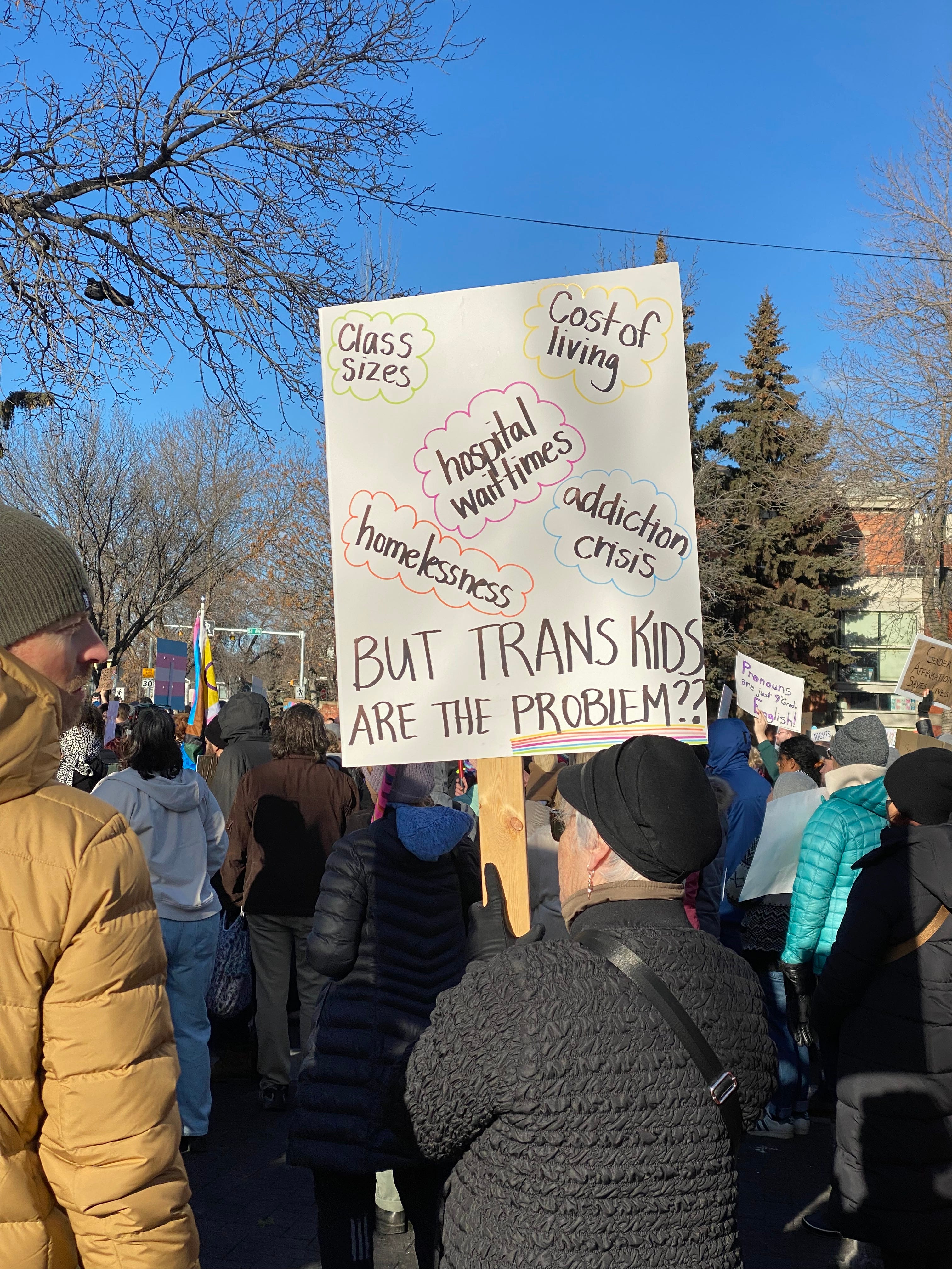
A culturally and socially evolving community is an enriched community, but not all agree, fanned by far right conspiracies, political rhetoric and social media. New immigrants, and jewish and palestinian populations have been targeted by far right groups, fanned by ugly political discourse on social media. Illicit drug use has lead to increases in addictions and overdoses. LGBTQ2S+ including trans individuals and groups have been targeted by the Alberta Government and in social media and on the street. The picture below is not from MacKinnon Ravine Park, but speaks to social unrest.
Still others despair over the existential threat of climate change, fear of the “other,” or fear of “being the other.” Settler colonial practices visited upon our first nation peoples have created generational problems that will take generations to address. A 2021 report stated that Alberta rates of mental illness are the worse amongst all the provinces, with 5-12% of the population needing hospitalization. Alberta is finding it difficult to attract new general practitioners and specialists (i.e., oncologists). It is near impossible to find a new doctor today even in major cities, a chronic issue in the smaller towns and rural areas. Alberta has some of the highest rates of utility costs, insurance rates, and some long standing insurance companies are fleeing the province.
These factors result in exhausting social and mental uneasiness and safety concerns for far too many in the community. Negative outcomes of these social realities are evidenced on our streets, parks, transit stations, and in our neighbourhoods.
2.5 Governance
2.5.1 River Valley Planning and Practice
The municipal development plan in Edmonton today is City Plan. Like its predecessors, it has multiple well meaning but competing aspirational policy statements dressed up in attractive graphics, including the river valley and parks, as well as trendy words.
The directives are somewhat refined in their parks master plan (i.e., Breathe). With respect to the river valley, the City currently has out for review a new Ribbon of Green (ROG) and North Saskatchewan River Valley Area Plan Bylaw. The previous documents were developed and approved in 1992 and 1985, respectively.
The new documents seek to provide a combined recreational parks plan set in a protected ecological system, areas of which have already been highly disturbed by coal mining, gravel and clay extraction. Over use and careless degradation of ecological heritages and safety of park users is a real concern (i.e., mountain bikers, electric bikes, scooters, skateboards, etc). The new ROG and “modernization” of the bylaw purports to adopt a more stringent ecological approach to on-going use, enjoyment and protection of the river valley, similar to past plans and bylaws. Specific implementation of both is still vague, and dependent on substantially increased funding. The funding discussion will occur at a later date. Moreover all existing approved concept plans have been grandfathered in to the ROG, and the population of the City will double - potentially doubling the number of river valley users. The public engagement approach to review the two documents adopted by the city is hurried and flawed. It is not at all clear that the new documents will adequately manage over use, competing needs and now understanding of how prioritization between competing needs and groups in the valley will occur. This topic will be the subject of a stand alone vlog … watch this space!
2.5.2 Park Planning Parameters and Standards
Since the early 1960s, parks have been planned based on a series of principles or parameters summarized in three categories: systems based; program focussed and, comprehensive construction standards. These principles and parameters are articulated in the parks masters plans of the day, that themselves support the municipal development plan of the day, as well as any and all bylaws and policies.
Land Systems Based. While parks are acquired and planned on a specific site basis, parks are planned on an integrated programmatic systems basis in new area plans, similar to roadways and utilities. The program of a single park is part of a larger park system, which is a collection of multiple overlapping programs meeting a huge diversity of needs. A river valley park system plan must link up and be part of table lands park planning. Yet until the early 70s, no river valley plan existed. Since the early 60s parks and schools have mostly co-located on sites to take advantage of the benefits of each others public assets for shared use (i.e., through the Joint Use Agreement). In recent years the City developed a ecological network strategy and plan to guide future land acquisitions on table lands, to be inform the school and park system plan, all within the 10% municipal reserve entitlements. The systems concept is outlined within in park master plans in sections referred to as either park typologies or park classification system, and are implemented in area plan. The river valley has its own area plan, that is currently out for public review.
Land Size and Configuration is Programmed Based. Parks inside and outside the river valley are planned to be four season, multi-use inclusive spaces including passive and active activities, as well as structured and unstructured activities, in both indoor and outdoor recreation facilities on publicly owned lands. Parks are designed to be four season multi-use site within a broader park system that accommodates all ages, incomes, gender, education, sexuality, cultures, etc. Parks are in fact a system of programs and activities systems dispersed across an urban landscape. In otherwords, area plans include a carefully designed systems of activities and amenities to meet nearby needs (i.e., playgrounds), close to home needs (i.e., field sports, community gardens), short distance drive or bike needs (i.e., recreation centres, community needs) serving multiple nearby neighbourhoods within a district or area plan, and drive to destination sites (i.e., river valley preservation areas). Think market areas for each activity for each type of indoor or outdoor constructed amenity.
Construction Standards. Development of amenities such as trails, washrooms, lighting, shelters, signage, boat launches, park furniture, soils, tree and shrub planting, etc are based on building codes and greenspace standards, articulated in a local construction standards manual. These standards are applied to ensure standard expectations for park users and construction project managers, as well as reduced long term maintenance costs. For example, a construction standards manual would include types of trees acceptable, spacing between trees, inspection requirements, soil depth and quality, etc. Similarly, when a paved trail is planned it is based on a standard width, base requirement, material requirement (asphalt, gravel, etc) and inspection requirements.
Operations/Maintenance. Most public green spaces including parks, road rights of ways and storm ponds except those liscensed to partners are maintained by the City (i.e., grass cutting, playground inspections and repairs, park furniture, hardsurface, lighting repairs, shelters, washrooms, etc and proactive tree maintenance. Maintenance cost projections and actuals take into consideration how maintenance activities are actually performed system wide in order to reduce costs (i.e., larger equipment, routing strategies, specialized/dedicated crews, etc). Natural areas retained have their own ecological assessment and plan to guide tree and other landscape maintenance, specific to the asset retained. Management and maintenance of our ecological heritages require specialized expertise to plan and implement. It is important that accepted assets are consistent with the construction standards manual to reduce long term maintenance costs. Annual maintenance costs over time will exceed the original capital construction costs.
An integrated administrative approach to park recreation, leisure, education and ecological services delivery that includes cross disciplinary planning, design, construction, programming and maintenance functions relies heavily on processes and relationships to balance or mediate between competing perspectives and needs.
The configuration of the site was based on the subdivision that occurred based and the lack of stability of the area (i.e., undevelopable land). This site is owned and maintained by the City Of Edmonton as part of the river valley park and trail system, including the trails, park furniture, signage, manicured portions of the site, and natural elements (i.e., bushes, trees, etc). The base of the trail is roadway based, not city trail construction standards.
2.5.3 Land Acquisition
The traditional perspectives of indigenous peoples of land that did not contemplate “ownership of land” was forcibly replaced by settler colonial legislation. That evolving legislation created private property regime, with privileged rights for landowners. Existing and future land uses are reviewed and approved my municipal government officials as per provincial planning legislation (i.e., the Municipal Government Act of Alberta, or MGA). These rules apply to both river valley and table lands. Municipal reserves (school and parks) up to 10% of the gross developable area, are taken as land, cash in lieu of land, or deferred reserve caveat, or combination thereof. In addition, lands deemed undevelopable can be taken/dedicated as environmental reserve, at no cost to the municipality. Table land parcels that cascade down into the river valley are often taken as environmental reserve.
River valley lands are most often acquired by environmental reserve taken at the time of subdivision. Other wholly located privately owned river valley lands must be purchased at market value by the municipality. River valley lands are often deemed unstable, subject to flooding, and therefore undevelopable, which means the value of the land is limited, but with enormous social and ecological value. The exchange value of the land is privileged in the MGA, not the latter.
What you see you see in the river valley is multiple titled parcels, often unconsolidated, owned by multiple individuals, groups and government, acquired in different sizes, shapes and time periods, using different methods (i.e., dedication, purchase). Land developed as public park lands are municipally owned, but not all river valley lands are publicly owned, but some private properties may look park like. Property lines are not visible, but are key element to understanding what can and cannot do in the river valley. The river itself, including the bed and shore, is provincial and federal government jurisdictions.
Elsewhere in the river valley, on a going forward basis, further expansion of the river valley park through purchase or subdivision of privately owned lands has been prioritized and budgeted (approximately $10M) by the City to be acquired through subdivision, opportunity purchase and/or direct contact with private landowners. This can be a bit of an iterative process that takes time. Remember river valley land acquisitions began over 100 years ago. The $10M will be inadequate as more than 100 properties have yet to be acquired in the river valley. Absent acquisitions of these private lands will ultimately limit both protection of natural heritages and completion of the river valley park system.
Park land titles are different than other land titles, and different than zoning. To repurpose parks they may have had a reserve designation on the title (lot 2R), older titles with a 2P, and some school land titles as 2SR. Some may be environmental reserve - 2ER. Some simply have a lot number. Some may be environmental reserve - 2ER. In all cases, in the past the City had to hold a public hearing to remove a reserve designation for park land parcels that includes a public hearing, signalling in the Municipal Government Act that these lands had a higher bar to repurpose than other lands. This is not to be confused with zoning.
Fortunately, MacKinnon Ravine is wholly publicly owned but its connection to that larger expanded park system will be somewhat compromised until it occurs. It may or could also be home to celebration of our indigenous history. And we gotta keep those engineers and corporate land management planners away too!
2.5.4 Co-Production of Place with Civil Society Partners
Planning legislation in Alberta does not accommodate park development of any kind, unless by a special agreement. Transforming “spaces” created in land use change processes into “places” are a multitude of deliberate acts that rely heavily on civil society. Fortunately, this site is wholly owned and developed without partners, so is less of an issue on this site, notwithstanding new future projects or. naturalization efforts that might or could arise as needs evolve.
2.5.5 Proposed National Urban Park
Since 2021, the City of Edmonton has been in discussion with project partners including Parks Canada, the Confederacy of Treaty Six First Nations, the Otipemisiwak Métis Government (formerly the Métis Nation of Alberta), and the Government of Alberta (in an observer role) about the potential for establishing a national urban park in the Edmonton region. Mackinnon Ravine Park may be part of that park.
The National Urban Park Initiative is expected to be a multi-phase, multi-year project, with opportunities for public and stakeholder engagement at all stages. Project partners are discussing what a national urban park could look like, but no decisions have been made to designate a national urban park at this time. This process may or may not include or impact this park, but it could.
Unilateral changes to Provincial government policy and legislation now requires the Province to “approve” any cost shared funding arrangements with the Federal Government. This unnecessary political initiative has effectively stalled the initiative for the time being, but there are efforts to re-invigorate it. This site could be part of the new Urban National Park, but likely would not materially effect this place.
Concluding Remarks
What you see when you visit the MacKinnon Ravine Park is a snap shot in time, in a specific season, and time of day. It is a beautiful landscape with a rich contested history and amazing views of the North Saskatchewan River and River Valley, with both manicured and naturalized landscapes and an undulating trail and trail system that is part of local, city wide, regional and national trail systems. But what IS this place about? Why is it important? Why are parks important? I leave you with a short story of mine why THIS park is important…
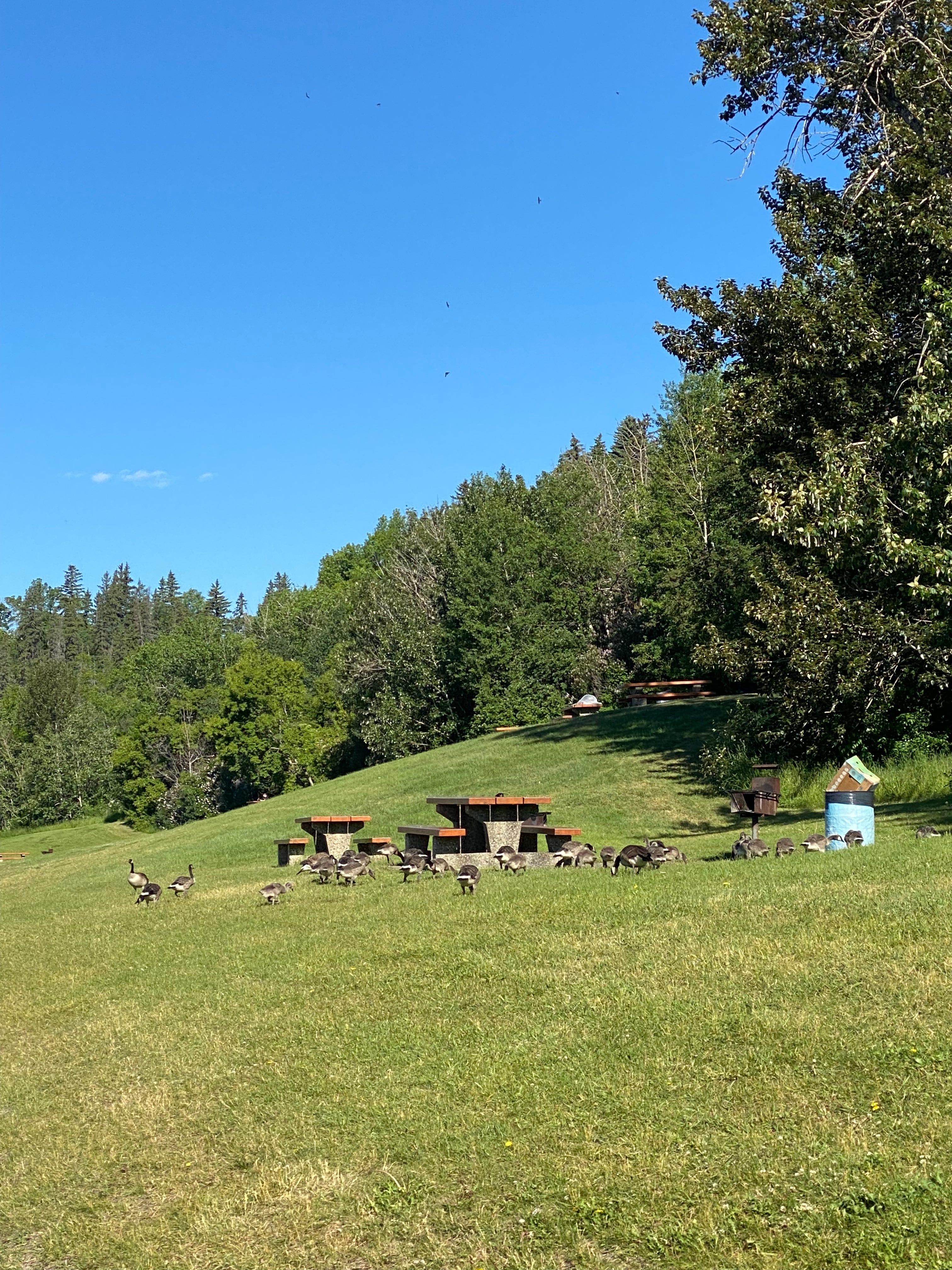
The flush of light green leaves signals that spring has arrived, along with the ritual return of canada geese. Solar powered walkers and bikers of all ages awake from their winter slumber and return to the park, some for fun and some commuting to work. Transiting the trail, I pass through aromas wafting with the smells of delicious thick beef burgers, hot dogs and and culturally diverse foods emanating from barbecues, sun tan lotions , cannabis, and the odd smelly biker (sorry that was me). I hear and see the sound of happy faces and voices on foot, in wheelchairs, bikes or scooters. I hear the hissing of protective Canada Geese, the barking dogs and or off leash and instictively want to stop and pet them. I glance at the seemingly ubiquitous rabbits and squirrels, plus the occasional coyote. Warm air washes over me, causing you to move to shady areas.
When I look and listen a little closer, I experience the rich diversity of Edmonton in this park with others. I see people of different colour, mixed race couples, hear different languages or broken english. I love seeing both unique and beautiful clothing (i.e., hijabs, niqabs, saris, keffiyehs, etc). Same sex and straight couples will display their affection for each other in the same ways as I do I noticeunfamiliar celebrations or games, and am curious. I witness once again how children are not born with prejudices.
I return to the park in the fall. Those same leaves turn first to a darker green, then later yellow, red and orange. The river valley is now awash in paint chip colours that would make any paint store proud to display, if not in travel magazines and Explore Edmonton brochures. MacKinnon Ravine is a place where I am transported out of my daily frantic mundane duties, demands and stresses: may my batteries are recharged spending time either alone ro with those that mean the most to me. I am with my people. Its also a place where I am visually reminded of the inequity of our society, encountering people in tents or pushing filled shopping carts discretely into their make shift homes. None of these latter visuals will make into travel magazines, nor would I want to rob them of their privacy and dignity.
There are a couple of interesting planning parallels from elsewhere in North America related to parks and planning specific to this site. First, the playground movement in North America was led by women in the fist half of the 20th century, that led to development of play spaces for children. This movement spread to Edmonton as well, and women lead the opposition to the freeway. Second, the Spadina Expressway contestation in Toronto started in the 40s, was partially built, but ultimately cancelled in 1971 due to community opposition. Collective action is slow to develop, but can be powerful, and can change planning processes and their outcomes.
The contestation in Edmonton on this site literally changed the way the City consulted with the community on land use planning files that would last until about the early 2000s (Bower 2016), but sadly has reverted to siding with the development industry. Evidence of this regression has been seen by expediting development processes, adoption of asymmetrical public engagement processes, and policy change privileging development of our most valuable lands for affluent landowners. (i.e., top of bank views and vistas). This is the ebb and flow of how institutions form, disappear, reform and evolve. I fear a downward flow…
This site is also representative of a disturbing legislative artifact about parks that make them catnip to development interests. Parks too often are viewed as an interim land use,a waiting for development to occur. They are exchangeable (financial) assets awaiting development or redevelopment to its “highest and best use.” This is flawed thinking as they are measured by other metrics (i.e., social, health and wellness, ecological goods and services). However, I understand why it is attractive for corporate land managers and developers to sell off park lands. One, they are owned by a single landowner, with whom which developers have a working relationship often including election donations. Two, they are typically environmentally clean lands, encumbered by buildings or utilities. Third, in mature areas of the city, there is no land left to develop, and none in parcels assembled in any size. In peri-urban areas, less park lands means more land for development for other uses. All of these factors combine to make park surplussing improv theatre, not long range planning.
Resources
Bower, Shannon Stunden. “The Affordances of MacKinnon Ravine: Fighting Freeways and Pursuing Government Reform in Edmonton, Alberta.” Urban History Review 44, 1-2 (2016): 59-72.