

Gallagher Park and the Cloverdale Community: Part II Hiding In Plain Sight (August 13, 2024)
Gallagher Park and the Cloverdale Community: Part II Hiding In Plain Sight (August 13, 2024)
Wicked parks planning problems...

Hiding In Plain Sight … (A.K.A. the source of Wicked Problems)
2.1 History and Culture
The Edmonton River Valley Conservation Coalition has published on its website an outstanding socio/cultural/ecological history of Edmontons River Valley called “A brief history of Edmontons River Valley and Ravine Park System.” It starts with a discussion of our indigenous peoples in the valley, long before settlers and settler colonialism arrived. There are multiple sites in our river valley where the presence of indigenous peoples have been found in close proximity to Gallagher Park, if not Gallagher Park itself. The link below is a summary of the river valley history. After Frederick Todd suggested the entire river valley be retained and kept as a park for people and nature in the early 20th century, the City set about to both acquire river valley lands, while simultaneously allow industrialization of it (i.e., coal mining, gravel mining, lumber mills, garbage dumps, etc), displacing indigenous peoples along the way. The link below is a summary of the river valley history.
https://www.ervcc.com/brief-history-of-nsr
2.2 Climate Change… Man Plans, God Laughs
Climate change will be an enduring reality, an outcome decades in the making, that can and will impact both this site and the entire river valley. The river valley is home to much revered mature trees and permeable surfaces, that both act to ingest moisture, sequester pollution, etc. As trees mature, the ability of them to survive increases with mature soil and root systems and fauna and flora ecosystems enclosed to some extent by the geomorphology (i.e.e steep grades). Edmonton has had periods of drought that stresses the trees. With or without the stress, urban forests are susceptable to fire. While fire is a normal regenerative process for forests, our river valley has largely protected from this natural process in order to protect people and urban infrastructure. Meanwhile, in recent years forest fires have ravaged the Province, displacing people and wildlife, and destroying forests at rates never seen before. To date this portion of the North Saskatchewan river valley has been spared… for now.
Areas bordering the river valley, the table lands, previously were previously permeable surfaces (i.e., trees, farmlands, wetlands). As urbanization occurs, those permeable surfaces are substantially replaced by impervious surfaces such as roads, buildings, etc. Climate change increases the intensity and frequency of weather. The moisture generated by those storms no longer sinks into the water table and ultimately into the river valley. Substantial portions of the the moisture are now directed from roof leaders, into storm sewers pipes directed into the river valley, in volumes and intensity never before seen, mitigated only somewhat by storm ponds. These storm events will increase the risk of river valley flooding, loss of our natural heritages, damage or loss of recreational amenities such as trails, bridges, lighting, buildings, signage, park furniture, etc., not to mention loss of indigenous history and culture. Critter and public health and safety is being compromised.
Wildfire equally threatens natural heritages and amenities. For decades we have sought to protect the river valley woodlands. The combination of this protection, periodic drought and wild wind events leaves the river valley natural heritages, wild life, people and property vulnerable. It is possible if not likely that these fires at some point could also spread on to the table lands at huge costs.
Densification of the table lands and climate change (i.e., more intense, frequent storm events), could exacerbate the potential flooding of the residential and potentially the existing support buildings and/or new event centre in Gallagher Park for the Ski Club and Folk Music Festival. It is likely that the LRT station has been designed to withstand flood conditions. Trails and the Muttart Conservatory are potentially at risk. The Pope John Paul Pavillion is likely safe as it is on higher ground but is vulnerable to fire. The trees that cascade down the side of the Gallagher hill could be at risk to drought conditions and wildfire, and if lost could compromise the stability of the hill itself.
2.3 Leisure and Recreation Benefits, Outcomes and Evolution of Needs
The benefits of sites like these meet City Plan goals for a sustainable city addressing social, ecological, individual and community health and wellness, and economic benefits. Public spaces provide places for community to decompress, connect with their neighbours, provide contact with nature, become active, experience health and wellness benefits and outcomes, reduce social intolerances, and build social capital. These benefits are typically not quantified in the same way land value is, have been extensively confirmed in the academic literature, and are part of any plan to create sustainable healthy communities and individuals.
But community needs are anything but static. As city populations grow, age and culturally diversify, recreation and leisure similarly evolve, and new recreational and leisure needs emerge. More women are active in sports, particularly in traditionally mens sports (i.e., hockey, soccer). We have seen the growth of electric bikes, scooters and skateboards, potentially creating safety problems for users on multi-use trails. Dog off leash areas have exploded in popularity and are now located across the city and the river valley. Outside of the river valley we see indoor soccer, gymnasium and pickleball spaces are in short supply, while minor hockey registrations are falling. Soccer was once an outdoor activity is now an indoor/ outdoor activity. Community gardens have exploded in numbers and participation. Accommodation of growing ecological, leisure and recreational needs are constrained by land availability.
The public has demanded a shifting of park space landscapes from primarily manicured spaces and fields to include more naturalized spaces and retention of natural areas in new plan areas. Indoor facility amenities have expanded to include fitness facilities, running tracks, steam rooms, saunas, diving tanks, wave pools, lazy rivers in combined ice/aquatic/soccer centres. Cultural groups seek to create places familiar with their or meaningful to their heritage (i.e., Chinese Garden and Shumka Stage in Louise MacKinney). Where once schools were located close to home as “walk to” facilities, we now see programs of choice (i.e., language, sport, culture, pedagogy, etc) where students travel across the city to attend. The public has asked for more access to the river itself for boating, fishing, tubing, etc. There are fewer schools but those that are constructed have much larger footprints. Land to meet the recreation and leisure community expressed needs is in short supply inside and outside the river valley. This evolution of needs will continue.
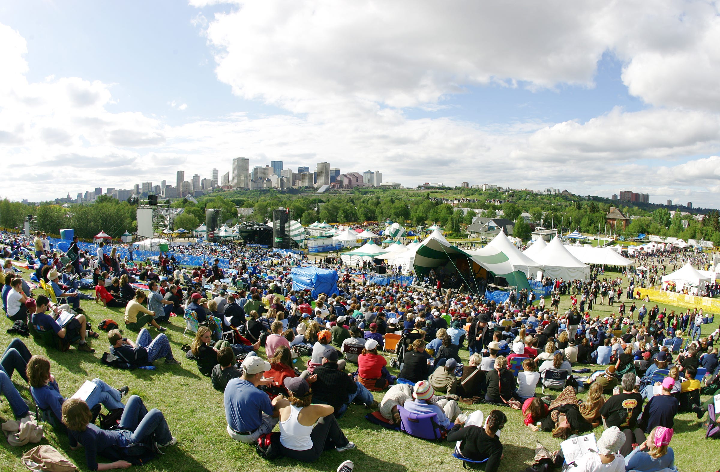
It is within this broader context where at Gallagher Park and its existing programming and activities exists. As the City population is projected to double in size, the demand for local downhill skiing will increase. The ski club has pledged to provide free skiing lessons. The growing immigrant population can be introduced to skiing and apres ski opportunities. The new ski club facility could be a base for more festivals or special events, both winter and summer, that also generate on and off site and service jobs (e.g., food preparation, supplies, print shops, etc). Existing or new festivals might or could be expanded into the site. The availability of the new LRT stop will make the park more accessible to all areas of the city, and the area more attractive to activity.


2.4 Social Setting
Alberta is a growing province with comparatively low housing costs and low rates of unemployment. However, the underlying economic system creates winners and losers. Wage disparity has grown dramatically since the early 80s concentrating wealth in the hands of the few, and importantly in the hands of national or international capital interests - including oil and gas, banks and residential investment trusts. That wealth has had growing influence over governance processes and outcomes (i.e., neoliberalism) in the form of expedited approval processes, disengagement of the community engagement, and alignment of public interests with business interests.
Housing affordability has declined starting in that same timer period caused by the financialization of the housing industry. Housing was long considered a social good, but has evolved since the 80s into a commodity owned by large companies (i.e., REITS) that use housing as a financial instrument for profit (Canadian Centre for Policy Alternatives). Locally, real estate agents report huge influxes of investment capital from both offshore and other parts of Canada. Housing in Edmonton is still relatively affordable compared to other parts of Canada and the world. This will increase housing purchases and rental prices. Transparency International has reported that Canada has long been known as a place for “snow washing” where questionable sources of foreign money is invested in canadian real estate (i.e., money laundering) In recent years, Covid was a major disruptor to the economy, jobs and job security. Dramatic rises in interest rate due in part to Covid has made home ownership even more unaffordable. Access to housing is different than access to affordable housing. This growing pre-carity of housing is financially, mentally and socially disruptive due to a loss of perceived control.
A culturally and socially evolving community is an enriched community, but not all agree, fanned by far right conspiracies, political rhetoric and social media. New immigrants, jewish and palestineian populations have been targeted by far right groups, fanned by ugly political discourse on social media. LGBTQ2S+ including trans individuals and groups have been targeted by the Alberta.
Still others despair over the existential threat of climate change, fear of the “other,” or fear of “being the other.” Settler colonial practices visited upon our first nation peoples have created generational problems that will take generations to address. A 2021 report stated that Alberta rates of mental illness are the worse amongst all the provinces, with 5-12% of the population needing hospitalization. Alberta is finding it difficult to attract new general practitioners and specialists (i.e., oncologists). It is near impossible to find a new doctor today even in major cities, a chronic issue in the smaller towns and rural areas. Alberta has some of the highest rates of utility costs, insurance rates, and some long standing insurance companies are fleeing the province.
These factors result in exhausting social and mental uneasiness as well as safety concerns for far too many in the community. Negative outcomes of these social realities are evidenced on our streets, parks, transit stations, in our neighbourhoods and of course in the river valley. As a partial solution, the impact of these can be mitigated through participation in positive recreation, leisure and social activities, all of which are available in Gallagher Park.
2.5 Governance
2.5.1 Land Acquisition
The traditional perspectives of indigenous peoples of land that did not contemplate “ownership of land” was forcibly replaced by settler colonial legislation. That evolving legislation created private property regime, with privileged rights for landowners. As such, river valley lands, as well as table lands, were effectively appropriated from indigenous populations.
Gallagher Park shown in the earlier graphic has been in the ownership of the City of Edmonton. Gallagher Park includes hill side, the Muttart Conservatory, the Edmonton Ski Club, and connecting trails. River valley lands are most often acquired by environmental reserve taken at the time of subdivision.
There is nothing to suggest municipally owned public lands in Cloverdale are at risk for sale, although there is in nearby Rossdale.
2.5.2 Parks Planning Parameters and Standards (river valley and table lands)
Since the early 1960s, parks have been planned based on a series of principles or parameters summarized in three categories: systems based; program focussed and, comprehensive construction standards. These principles and parameters are articulated in the parks masters plans of the day, that themselves support the municipal development plan of the day, as well as any and all bylaws and policies.
Land Systems Based. While parks are acquired and planned on a specific site basis, parks are planned on an integrated programmatic systems basis in new area plans, similar to roadways and utilities. The program of a single park is part of a larger park system, which is a collection of multiple overlapping programs meeting a huge diversity of needs. A river valley park system plan must link up and be part of table lands park planning. Yet until the early 70s, no river valley plan existed. Since the early 60s parks and schools have mostly co-located on sites to take advantage of the benefits of each others public assets for shared use (i.e., through the Joint Use Agreement). In recent years the City developed a ecological network strategy and plan to guide future land acquisitions on table lands, to be inform the school and park system plan, all within the 10% municipal reserve entitlements. The systems concept is outlined within in park master plans in sections referred to as either park typologies or park classification system, and are implemented in area plan. The river valley has its own area plan, that is currently out for public review.
Land system planning direction is provided in park master plans. There have been multiple plans developed and implemented over time, including the 1970-1980 City of Edmonton Parks Master Plan, the 1979-1983 Parks Master Plan, the Parks Management Plan (1985-2005), the 2006-2016 City of Edmonton Urban Management Plan, and Breathe (2017). Each has included some form of a parks typology used to allocate new parks and park systems across an urban landscape (i.e., area plans). Each plan reflects ever changing recreational, leisure and school planning needs.
Land Size and Configuration is Programmed Based. Parks inside and outside the river valley are planned to be four season, multi-use multi-functional inclusive spaces including passive and active activities, as well as structured and unstructured activities, in both indoor and outdoor recreation facilities on publicly owned lands. Parks are designed to be four season multi-use site within a broader park system that accommodates all ages, incomes, gender, education, sexuality, cultures, etc. Parks are in fact a system of programs and activities systems dispersed across an urban landscape. In otherwords, area plans include a carefully designed systems of activities and amenities to meet nearby needs (i.e., playgrounds), close to home needs (i.e., field sports, community gardens), short distance drive or bike needs (i.e., recreation centres, community needs) serving multiple nearby neighbourhoods within a district or area plan, and drive to destination sites (i.e., river valley preservation areas). Think market areas for each activity for each type of indoor or outdoor constructed amenity.
Construction Standards. Development of amenities such as trails, washrooms, lighting, shelters, signage, boat launches, park furniture, soils, tree and shrub planting, etc are based on building codes and greenspace standards, articulated in a local construction standards manual. These standards are applied to ensure standard expectations for park users and construction project managers, as well as reduced long term maintenance costs. For example, a construction standards manual would include types of trees acceptable, spacing between trees, inspection requirements, soil depth and quality, etc. Similarly, when a paved trail is planned it is based on a standard width, base requirement, material requirement (asphalt, gravel, etc) and inspection requirements.
Operations/Maintenance. Most public green spaces including parks, road rights of ways and storm ponds except those liscensed to partners are maintained by the City (i.e., grass cutting, playground inspections and repairs, park furniture, hardsurface, lighting repairs, shelters, washrooms, etc and proactive tree maintenance. Maintenance cost projections and actuals take into consideration how maintenance activities are actually performed system wide in order to reduce costs (i.e., larger equipment, routing strategies, specialized/dedicated crews, etc). Natural areas retained have their own ecological assessment and plan to guide tree and other landscape maintenance, specific to the asset retained. Management and maintenance of our ecological heritages require specialized expertise to plan and implement. It is important that accepted assets are consistent with the construction standards manual to reduce long term maintenance costs. Annual maintenance costs over time will exceed the original capital construction costs.
An integrated administrative approach to park recreation, leisure, education and ecological services delivery is required that includes cross disciplinary planning, design, construction, programming and maintenance functions balance or mediate between competing perspectives and needs. That integrated administrative approach should be housed in a single entity focussed on parks, natural areas and the environment. The current structure distributes park sub-functions across the administration which results in disjointed and or disconnected approaches to land and services management. This has had negative implications on multiple sites and the system more broadly.
2.5.4 Co-Production of Place
“Spaces” created in land use change processes are transformed into “places”1 like Gallagher Park through multiple deliberate acts of both state and non state actors (i.e., civil society). I have termed the efforts of civil society as the kinetic engagement of the community, which requires support and participation of volunteers to deliver recreation and leisure services. In this case, not-for-profit entities (i.e., Ski Club, Indigenous Youth Sport Group, Folk Music Society) operate in different seasons of the year, and are now collaborating on the development of a shared facility to support both organizations and activities. Both groups are provided access to city land at no cost. The City funds about 25% of the funding for the Folk Music Festival, but that event relies heavily on the business community, the Edmonton Community Foundation, art group grants, ticket sales, concessions, etc for the rest of its operational funding, with multiple benefits enjoyed by local businesses in Cloverdale and elsewhere.
2.5.3 River Valley Park Development and Management.
In the early 60s the Province of Alberta amended planning legislation to require more rigorous planning approaches and processes, including the development and adoption of General Municipal Plans, today called Municipal Development Plans. There have been multiple municipal development plans over time. Todays version is called City Plan. These plans are reviewed and updated about every 5-10 years each with high level competing policies and directives.
One of those outcomes of that change in governance was the requirements for sub area functional master plans, including parks, roads and utilities. The 1970-1980 Edmonton Parks Master Plan led by the Parks and Recreation Department and the Parks Superintendent was the first parks master plan in the history of the city, and included the river valley. More formal river valley park planning occurred in the early 70s through the creation of the Capital City Recreation Park, and in the early 90s CCRP was extended by the Ribbon of Green.
CCRP led by the Parks and Recreation Department turned disturbed landscapes (i.e., clay/brickyards, coal and gravel extraction, lumber harvesting and mills, garbage dumps) and undisturbed landscapes into publicly accessible green landscapes accommodating recreation facilities, sportsfields, picnic areas, trees, water play features, golf links, trails, vistas, viewpoints, frisbee golf, contact with nature, etc.
The planning for the CCRP in the 1970s envisaged and began to fund the development of a Central River Valley Park in the Rossdale, Cloverdale and Riverdale Communities. All three communities are located inside the river valley. The province funded land acquisitions in these communities in furtherance of the central park concept. In the mid 80s due to public pressure from existing residents and the development industry, the City backtracked on this strategy. Properties already purchased were sold. The Cloverdale residential area today is a mix of market priced small older homes, redeveloped larger homes and condominiums. Housing in this area would not be deemed “affordable” housing, but does increasingly include multi-family housing sites.
As CCRP was being implemented, the Planning Department created and implemented the North Saskatchewan River Valley Bylaw (1982) to limit river valley development to parks and preservation of ecological heritages. Around the same time, the Planning Department created a Top of Bank policy to preserve “parkways” as defined by the 1970-1980 Parks Master Plan as public lands along river valley and ravine and ravine interfaces. Development wished these lands to be set aside for high end residential single family development. This conflict would play out over the following 3 decades.2
In the early 90s, the Parks and Recreation Department realized a plan was needed to extend the existing CCRP plan in an initiative called the Ribbon of Green (1992). The vision for that plan saw protection of a ribbon of green through the valley protecting natural features, wildlife, vegetation and cultural heritages while providing recreational opportunities for community wide health and wellness. Five principles included conservation, recreation, development, trails and education.
In the mid 90s as funding was beginning to dry up for river valley park amenity development, just as it had for table land parks in the early 80s. Parks and Recreation reached out to other river valley communities, from Fort Saskatchewan in the east to Devon in the west, to develop a regional natural parks system and plan that would working together would acquire funding from other levels of government and philanthropic organizations.
That regional 25 year vision came together in the River Valley Alliance Plan of Action approved by Edmonton City Council and 8 other municipalities in 2007, that proposed $300M dollars of improvements, including bridges, trails, amenity shelters, signage, etc. The Plan of Action stretches 88km between Fort Saskatchewan, through Edmonton to Devon in the west, an area of about 7300 acres. The development of the regional plan inside the Corpration was led by the parks functions once again. The Plan of Action included three pillars: environment, society and economic. That plan of action included development of three river crossings (i.e., bridges), multiple kms of asphalt trails, mechanized river valley access, the Louise McKinney Promenade, way finding signage, etc.. These project were completed with detailed environmental impact assessments, site selection studies, public engagement and approved by council in processes that included both budget approvals and public hearings. Much of that capital work is now complete, with the exception of trails some final trail links, completed at enormously reduced costs (2/3) to local municipalities.
Two major park master plans were approved since 2000. The 2006-2016 Urban Parks Management Plan was approved. It included principles for an enhanced focus on conservation of natural heritages inside and outside the river valley, equitable services for all regardless of age, income, culture, religion, gender or sexuality. It was based on systems of program systems. Breathe approved in 2017, took both a higher level ecological perspective. It also replaced a program need perspective (i.e., playgrounds, sports fields, recreation centres) with a neoliberal planners land based approach to park land provision (i.e., proximity to parks, amount of park lands) - shattering the systems approach inside and outside the river valley.
A comprehensive long term vision for Gallagher Park was developed in 2021 to identify future needs, goals and outcomes that supported enhanced development and use for recreation, wellness, celebration while protecting the ecological heritages, using Breathe as an input. This plan development included public engagement. A link to the document is provided below. There is signage on the site regarding the new ski club, but no information that shares the broader strategy.
https://www.edmonton.ca/sites/default/files/public-files/assets/PDF/Gallagher_Park_Concept_Plan.pdf
Using Breathe the City has been updating and extending the Ribbon of Green as well as the North Saskatchewan River Valley Area Bylaw. Both of those plans are currently out for public review. The vision of the revised Ribbon of Green is as follows:
The North Saskatchewan River Valley and Ravine System is a protected, connected, ecologically resilient landscape that honours our collective history and promotes healthy living through diverse opportunities for recreation, active transportation, learning, and gathering in the tranquility of nature.
Ribbon of Green 2024, Page 12
2.5.4 Proposed National Urban Park
Since 2021, the City of Edmonton has been in discussion with project partners including Parks Canada, the Confederacy of Treaty Six First Nations, the Otipemisiwak Métis Government (formerly the Métis Nation of Alberta), and the Government of Alberta (in an observer role) about the potential for establishing a national urban park in the Edmonton region.
The National Urban Park Initiative is expected to be a multi-phase, multi-year project, with opportunities for public and stakeholder engagement at all stages. Project partners are discussing what a national urban park could look like, but no decisions have been made to designate a national urban park at this time. This process may or may not include or impact Gallagher Park, but it could. Moreover, the Provincial government recent legislation may slow down or scrub the new proposal for political reasons.
My Take… A Wicked Planning Problem
Gallagher Park aligned well with the CCRP and subsequent Ribbon of Green documents, and its future is very bright. Its program and associated community benefits are expanding, and will draw more people into the river valley. It is a well known year round gathering place that provides multi-functional activities and benefits, including health and wellness, social, cultural, economic and ecological goods and services benefits in winter and summer, and is even more accessible than before given the opening of the LRT station in the northwest corner of the greenspace.
The success of Gallagher Park, its programming and amenities within the broader river valley park system highlights a planning conundrum, sometimes described as wicked planning problems. Wicked planning problems (see resource below) are those with multiple characteristics - the root causes are ill defined, have unclear causalities, there is not one way to solve the problem but there are multiple intervention points, there are multiple stakeholders with unaligned world views, decisions are reliant on political judgement. Solutions are impacted by external forces or factors on multiple levels (i.e., local, provincial, national, international), nor can they be solved by a single type of expertise. Social actors have different levels of access to knowledge and different levels of agency in processes. Planning scholar Donald Schon in 1979 said the policy process, which drives decision making, is a “swampy lowland” where solutions are “confusing messes” incapable of technical solutions. I have made this same policy observation (less eliquently) in my own research on park land decision-making in Edmonton in the 1960-2010 period. Commonly cited examples of wicked problems include climate change, sustainability, poverty, obesity, homelessness, affordable housing, etc.
The population of the city is planned to double, that will result in more people in the valley. Moreover, as the city densifies, there will be less private spaces. There are multiple planning conundrums, or wicked planning problems. At the highest level, how can we protect the river valley from ecological degradation and promote recreational and leisure uses? Lets unpack this in a more granular fashion.
What uses are appropriate to be located in the river valley, and to what intensity? The planning goals of the Ribbon of Green and the modernization of the River Valley Bylaw are to protect the river valley from over use and environmental degradation while simultaneously promoting recreation and leisure activities. Inevitably, conflict will arise between the two. Can both of those outcomes be achieved? If so, what are its metrics, how is it to be measured, and who by?
How can interfaces between uses and users be effectively managed to reduce or eliminate over use or misuse? Beyond public education and design strategies, how can river valley misuse be physically managed (i.e., fencing, police, fire, volunteers, etc)? There are multiple of river valley park system accesses (i.e., roads and parking lots, trails, stair ways, a mechanized river access in the downtown), yet inappropriate or unwanted uses or activities exist today (i.e., feral mountain bikers “creating” trails into ecological areas areas, poverty/homeless encampments, drug use, crime, etc).
How can we protect the river valley from actions that occur outside the river valley? City approved table land residential development approaches are literally planning to remove mature tree canopies, permeable surfaces (i.e., backyards) on private lands to address housing affordability.3 In those same areas, the City is actively selling off publicly owned permeable surfaces (i,.e, portions of parks) to developers for higher density market housing.4 In new areas, permeable farmlands and wetlands will be developed as large masses of high density of residential development in addition to roadways. This loss of table land permeable surfaces will (a) create urban heat islands (b) will result in flooding and wildfire in the river valley by climate change induced extreme weather patterns. Loss of natural heritages, infrastructure and life will result. The climate change induced wild storm events are the quintessential definition of a super wicked problem.
My take is not to provide “the” definitive answer to what is appropriate or not in the river valley. However adopt a transparent systems approach that includes informed and on-going community engagement that doesn’t start and end in land use change processes. A more rationale organization structure would facilitate that outcome.
Resources
History of Cloverdale (Lawrence Herzog)
https://web.archive.org/web/20100224024738/http://www.rewedmonton.ca/content_view2?CONTENT_ID=468
Working with wicked problems: Philippe Vandenbroeck at TEDxUHowest
“Spaces” are defined by property lines in land use change process. “Spaces” are transformed into “places” when the community becomes engaged and the public attach meaning to the site, based on their role in creating amenities and use of them.
A change in this policy in 2010 promoted by development interests and friendly administrators meant effectively only narrow strips of lands behind starter castles would be accessible to the public.
Housing affordability is the product of the financialization of the housing industry by banks and land developers seeking to maximize profit. These entities have no obligation to provide affordable housing.
There is no shortage of residential lands in approved area plans that would necessitate the sale of park lands. This represents an extreme example of neoliberalism where economic interests interests are privileged over social, health and wellness and ecological benefits. The City could instead retain these sites to meet their future tree planting goals. They partner with communties to fund tree planting initiatives.